5/20/05 to 5/22/05
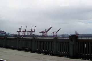
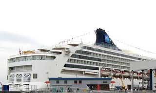
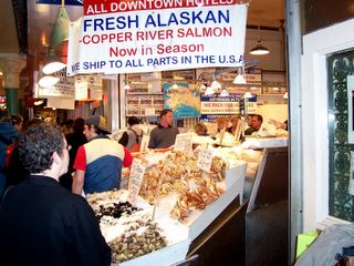
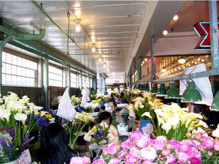
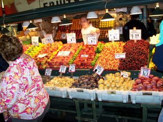
We moved on to the Seattle, Washington area. We are staying at the Tall Chief RV Resort in Fall City. It again is heavily wooded. It rained on us most of the way and then most all day long after arriving. It is quite cool also. Seattle is a beautiful city. I think one of the cleanest big cities we have been in. The road sides along the interstates are landscaped and so clean. Downtown has been renovated where necessary and the businesses there are thriving unlike most downtown larger cities. The waterfront on Puget Sound has several cruise ships arriving and departing each week. The other major boon to the economy from the shipyard is container shipping. Containers like you see on railroad cars and trucks on the highway. They have huge cranes that can load a ship in 24 hours. Seattle has a market square which sells everything imaginable but especially fruits and veggies and fish and seafood. They also sell flowers of every kind and color. They are so beautiful. We enjoyed walking through this area. Pioneer Square is the old original part of town. In the early 1900’s they had a fire which burned down most of this area. Before rebuilding a law was passed that allowed them to rebuild only with stone or brick, no wood. The buildings in this area are beautiful. The designs of the building fronts are each unique. It is just an awesome place to visit. Then of course they have the space needle which is some 600+ feet high. We did not go up in it. We did enjoy a very good seafood lunch down on the waterfront and enjoyed walking through the area.
Sunday, May 22, 2005

Thursday, May 19, 2005
5/19/05
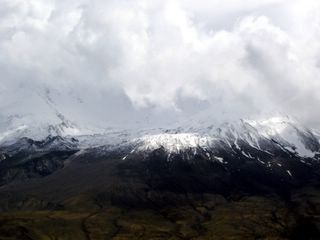
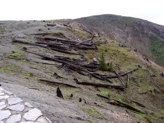
We are stayed at Seaquest State Park which is at the entrance to the north highway leading to Mount Saint Helens. Again it was rainy and quite cool. We left about noon today to go to Mt. Saint Helens not knowing whether we would see much of the volcano because of the clouds. It is a 50 mile trip up and down mountains and through a heavily wooded area. About 20 miles before reaching the Johnston Viewing Center we began to see the devastation from this volcano. On May 18, 1981 it began with a 5.1 magnitude earthquake which triggered the collapse of the north side of Mt. Saint Helens. This formed the largest landslide in recorded history. In less than four minutes the blast flattened 230 square miles of forest. Trees over 10 miles north of the volcano were toppled by the 300-mile per hour blast. The plume of volcanic ash billowed 15 miles into the sky. In some areas the trees were planted back and are growing. But in the actual National Monument area no changes have been made so that geologists can observe the regrowth of the vegetation and animals. The trees in some areas are growing back. It is an awesome sight and sure shows the power of nature. When we arrived at the viewing center the mountain was nearly covered with clouds. We watched a movie about the eruption and then waited patiently for the clouds to move. The statistics we heard about this massive eruption were almost unbelievable. Finally the clouds did move so that we could get some good pictures but still not completely cloudless. It was most interesting to see the results of this horrible act of nature.
We are stayed at Seaquest State Park which is at the entrance to the north highway leading to Mount Saint Helens. Again it was rainy and quite cool. We left about noon today to go to Mt. Saint Helens not knowing whether we would see much of the volcano because of the clouds. It is a 50 mile trip up and down mountains and through a heavily wooded area. About 20 miles before reaching the Johnston Viewing Center we began to see the devastation from this volcano. On May 18, 1981 it began with a 5.1 magnitude earthquake which triggered the collapse of the north side of Mt. Saint Helens. This formed the largest landslide in recorded history. In less than four minutes the blast flattened 230 square miles of forest. Trees over 10 miles north of the volcano were toppled by the 300-mile per hour blast. The plume of volcanic ash billowed 15 miles into the sky. In some areas the trees were planted back and are growing. But in the actual National Monument area no changes have been made so that geologists can observe the regrowth of the vegetation and animals. The trees in some areas are growing back. It is an awesome sight and sure shows the power of nature. When we arrived at the viewing center the mountain was nearly covered with clouds. We watched a movie about the eruption and then waited patiently for the clouds to move. The statistics we heard about this massive eruption were almost unbelievable. Finally the clouds did move so that we could get some good pictures but still not completely cloudless. It was most interesting to see the results of this horrible act of nature.
Wednesday, May 18, 2005
5/14/05 to 5/18/05
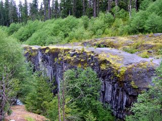
We made our way to Vancouver, Washington staying at the Big Fur Campground. It was very heavily wooded as the name suggests. The Columbia River Gorge is the dividing line between Oregon and Washington. There is a scenic highway along each side of the river, one is Oregon and one is Washington. This was a beautiful drive, especially on the Oregon side. There are several beautiful water falls in the area, actually 77 water falls. The most spectacular is The Multnomah Falls. It is 200 feet high divided into 2 separate waterfalls. It is a spectacular sight. We had a great time seeing the beautiful mountains, canyons and the waterfalls. On Wednesday we took the highway to the south side of Mt. Saint Helens. This day was the 25th anniversary of the volcano eruption. We were able to walk a trail to a canyon that was created during the volcanic eruption. Geologists have determined that the canyon was actually formed thousands of years ago from another volcano and had over the centuries filled in and was covered with vegetation. The strong force of the eruption in 1980 formed the canyon again. We saw other results of the volcano and picked up some pieces of volcanic rock. Most of the damage and sights are around on the north side of the mountain which we hope to see on Thursday. The weather while we were in the area was very cloudy with spotty rain. However it turned out that every time we wanted to get out of the truck the rain let up.
We made our way to Vancouver, Washington staying at the Big Fur Campground. It was very heavily wooded as the name suggests. The Columbia River Gorge is the dividing line between Oregon and Washington. There is a scenic highway along each side of the river, one is Oregon and one is Washington. This was a beautiful drive, especially on the Oregon side. There are several beautiful water falls in the area, actually 77 water falls. The most spectacular is The Multnomah Falls. It is 200 feet high divided into 2 separate waterfalls. It is a spectacular sight. We had a great time seeing the beautiful mountains, canyons and the waterfalls. On Wednesday we took the highway to the south side of Mt. Saint Helens. This day was the 25th anniversary of the volcano eruption. We were able to walk a trail to a canyon that was created during the volcanic eruption. Geologists have determined that the canyon was actually formed thousands of years ago from another volcano and had over the centuries filled in and was covered with vegetation. The strong force of the eruption in 1980 formed the canyon again. We saw other results of the volcano and picked up some pieces of volcanic rock. Most of the damage and sights are around on the north side of the mountain which we hope to see on Thursday. The weather while we were in the area was very cloudy with spotty rain. However it turned out that every time we wanted to get out of the truck the rain let up.
Friday, May 13, 2005
5/8/05 to 5/13/05
We left with the weather cloudy but as we traveled along we saw more and more beautiful sunshine. The Oregon coast line is spectacular with large rocky peaks in and near the coast. It is picture perfect country. We crossed the highest bridge in Oregon. The gorge below was spectacular. We sill sure be glad when we have a camera again.
The mountains we pass through are completely covered with trees a lush green. We are seeing very few wild flowers. We just heard on the radio it is supposed to rain today. with snow in the upper elevations however the sun is shining now with beautiful clouds. We have passed through an area with a small town that looks like it could be a small town in Kansas. Logging is a big resource in Oregon and in Coos Bay we saw a very large ship that is used to transport logs overseas. As we got closer to our destination we saw miles and miles of sand dunes along the coast. The dunes run along the coast for about 50 miles. It is a big tourist attraction here. We are staying at Lakeshore RV Park which is three miles south of Florence, Or. We will be staying here for one week. Florence has a lovely renovated downtown right next to the river with a wharf there. We walked around the shops and along the wharf and enjoyed the nice sunny afternoon. The next day it began raining and rained off and on the rest of the time we were at this campground.
We needed to pick up our mail and buy some groceries so we ignored the rain. Wednesday we took a side trip to Coos Bay, Or. This is a small town that originally was founded around coal mines. Now it is a logging area. We saw many logging trucks on the highways. There is a very large ship docked that is being loaded with logs. Also there are many huge piles of logs waiting to be loaded. There is no waste byproduct with this wood. Every part of the tree is sold for some purpose. We made a trip down to the beach in Coos Bay which seems to be used mostly for 4-wheelers. The sand dunes are right up next to the beach. The sand dunes start here at Coos Bay and run all the way up the coast past Florence which is about 50 + miles. On Thursday we went north to an area where sea lions congregate in cave like areas in the bluffs. We were able to see one small one in the water and a couple sunning on a rock. We also took some pictures of the Heceta Light House. This is supposedly the most photographed light house in the US. Today was a beautiful day and we enjoyed the beauty. Friday we took a side trip to an Aquarium in Newport. On the way we stopped by a couple of beaches along the way. Each was very different. One had lots of large rocks and the other was nothing but sand. The aquarium was a great place to visit. The fish and creatures that live in the sea are certainly more colorful than those on land with such bright colors and unusual shapes. It was amazing to us.
Saturday, May 07, 2005
5/3/05 to 5/7/05
Our camera is not working so I will have no pictures today. As we leave Stone Lagoon Campground it is a little foggy especially as we climb into the mountains but soon it dissipates and the sun comes out. The first 20 miles we have seen before as we traveled through the Redwoods yesterday. The summit of a long stretch of climbing is 1,475 feet. That does not seem like much except just a couple of miles back we were at sea level. We saw some redwood trees, not any big ones though. In this area are beautiful canyons which are completely covered with trees. Beautiful. We are dropping down now next to the ocean. We are next to the ocean for about 2 – 3 blocks and then start climbing back up again until we are up very high on a bluff. We can see the ocean but not very easily as there is a great deal of fog here. Still climbing we turned away from the coast into a wooded area again with the giant redwoods. We drive through several miles of the forested mountains until we drop down into a valley. In this area there are several fields of Lilies being grown to sell. Some were Easter Lilies but not sure about all of them. They are just small plants so they are not blooming. We will be staying at a campground, Salmon Harbor Resort, in Smith River, Ca. This is just 8 miles from the Oregon border. We are glad for that as prices here in California are too high. We are counting on them being a little more reasonable in Oregon. This town is on the mouth of a river that feeds into the ocean. We can see the ocean and a lighthouse as we sit in our living room. We plan to stay here for 5 days hoping to visit some of the beautiful areas around here and to do some more beach combing. It has rained most of the time we have been here, not hard but not very nice for traveling around. We went to the towns both north and south of us on several occasions. On Wednesday we went north to Brookings, Oregon, 3 miles away, to shop for a new camera at Walmart. We found a tourism center and were told there is no Walmart in this town. We did drive around there to see the wharf there and just to see what this town was “all about”. Then we drove back to Smith River which is south of our campground. We found a Walmart there and stocked up on groceries and looked at the cameras. We also went to Pebble Beach where people hunt for Agate. I talked to a lady who told me what I should look for. She found several and gave them to me. I had fun hunting but came home with mostly pretty rocks. Thursday we stayed home all day. Friday we took Highway 199 northwest through another National Forest with beautiful views. A river ran alongside the road most of the way. It was foggy and misting so we did not go very far but we did see some more of the big Redwoods and scenery of the river that ran along side of the road. Saturday morning looked like it might quit raining. Since we have NO cell phone service here and I am having internet withdrawal we decided to try to find an area where I could get on the internet to read the email and we could make some phone calls. We were able to make phone calls but still could not connect to the internet. We ate lunch at a seafood place and then came home. Tomorrow we will leave here without accomplishing much.
Our camera is not working so I will have no pictures today. As we leave Stone Lagoon Campground it is a little foggy especially as we climb into the mountains but soon it dissipates and the sun comes out. The first 20 miles we have seen before as we traveled through the Redwoods yesterday. The summit of a long stretch of climbing is 1,475 feet. That does not seem like much except just a couple of miles back we were at sea level. We saw some redwood trees, not any big ones though. In this area are beautiful canyons which are completely covered with trees. Beautiful. We are dropping down now next to the ocean. We are next to the ocean for about 2 – 3 blocks and then start climbing back up again until we are up very high on a bluff. We can see the ocean but not very easily as there is a great deal of fog here. Still climbing we turned away from the coast into a wooded area again with the giant redwoods. We drive through several miles of the forested mountains until we drop down into a valley. In this area there are several fields of Lilies being grown to sell. Some were Easter Lilies but not sure about all of them. They are just small plants so they are not blooming. We will be staying at a campground, Salmon Harbor Resort, in Smith River, Ca. This is just 8 miles from the Oregon border. We are glad for that as prices here in California are too high. We are counting on them being a little more reasonable in Oregon. This town is on the mouth of a river that feeds into the ocean. We can see the ocean and a lighthouse as we sit in our living room. We plan to stay here for 5 days hoping to visit some of the beautiful areas around here and to do some more beach combing. It has rained most of the time we have been here, not hard but not very nice for traveling around. We went to the towns both north and south of us on several occasions. On Wednesday we went north to Brookings, Oregon, 3 miles away, to shop for a new camera at Walmart. We found a tourism center and were told there is no Walmart in this town. We did drive around there to see the wharf there and just to see what this town was “all about”. Then we drove back to Smith River which is south of our campground. We found a Walmart there and stocked up on groceries and looked at the cameras. We also went to Pebble Beach where people hunt for Agate. I talked to a lady who told me what I should look for. She found several and gave them to me. I had fun hunting but came home with mostly pretty rocks. Thursday we stayed home all day. Friday we took Highway 199 northwest through another National Forest with beautiful views. A river ran alongside the road most of the way. It was foggy and misting so we did not go very far but we did see some more of the big Redwoods and scenery of the river that ran along side of the road. Saturday morning looked like it might quit raining. Since we have NO cell phone service here and I am having internet withdrawal we decided to try to find an area where I could get on the internet to read the email and we could make some phone calls. We were able to make phone calls but still could not connect to the internet. We ate lunch at a seafood place and then came home. Tomorrow we will leave here without accomplishing much.
Monday, May 02, 2005
5/1/05 to 5/2/05
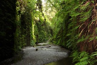
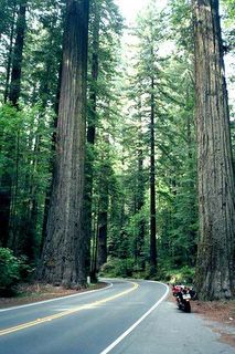
Today we left the campsite at Willits and headed up Highway 101 with our destination to be Stone Lagoon Campground outside of Trinidad, Ca. The highway was again a winding road with many mountains to go up and down. We were inland most of the way. There was a beautiful river than ran beside the highway which was very pretty. Some of the time we were in a heavily wooded area. Quite a few of the trees were Giant Redwoods. We saw one large tree that had a door in it. “A real tree house” the sign said. We also saw a very large redwood log which had been hollowed out and made into a house. Our campground is quite close to the ocean. There are several inlets here called lagoons that flow out to the ocean. Also very close by is the Redwood National Park. We took several side trips through the Redwood Forest. It is beautiful scenery. The trees are so tall you cannot see the tops of them. The forest floor has some wild flowers, lots of ferns, wild berries, mosses, and other unknown vegetation. We were up on high mountains and down on the seashore. We walked along the beach and found some sand dollars and some pretty colored rocks for our granddaughter. We hiked back to an area called Fern Canyon. This canyon had high cliffs which are covered with several different kinds of ferns. It is beautiful. A stream runs between the walls. There are some wild flowers and wild life. It is kind of like a rain forest. We had a great day exploring the Redwood National Park.
Today we left the campsite at Willits and headed up Highway 101 with our destination to be Stone Lagoon Campground outside of Trinidad, Ca. The highway was again a winding road with many mountains to go up and down. We were inland most of the way. There was a beautiful river than ran beside the highway which was very pretty. Some of the time we were in a heavily wooded area. Quite a few of the trees were Giant Redwoods. We saw one large tree that had a door in it. “A real tree house” the sign said. We also saw a very large redwood log which had been hollowed out and made into a house. Our campground is quite close to the ocean. There are several inlets here called lagoons that flow out to the ocean. Also very close by is the Redwood National Park. We took several side trips through the Redwood Forest. It is beautiful scenery. The trees are so tall you cannot see the tops of them. The forest floor has some wild flowers, lots of ferns, wild berries, mosses, and other unknown vegetation. We were up on high mountains and down on the seashore. We walked along the beach and found some sand dollars and some pretty colored rocks for our granddaughter. We hiked back to an area called Fern Canyon. This canyon had high cliffs which are covered with several different kinds of ferns. It is beautiful. A stream runs between the walls. There are some wild flowers and wild life. It is kind of like a rain forest. We had a great day exploring the Redwood National Park.
Sunday, May 01, 2005
Below are our travels from 4/19 to 4/30.
4/19/05
We left Barstow area and headed on Highway 58 with a destination of Bakersfield Wal-Mart Parking Lot. After leaving Barstow we saw many fields of fruits and vegetables. Then soon we saw no more towns or fields, only desert again. We saw a few wildflowers along the way but not much of anything else. We passed through Boron, Ca. where Borax is manufactured. Borax has been mined here for many years. Go to http://www.borax.com/index.html to find out about this mfg.and the uses of Boron.
We did finally come to a mountain range around Mojave, Ca. There we discovered a wind generating farm. http://www.tehachapi.com/wind/ This is supposed to be one of the windiest places in the world. We were heading into the wind so it did not seem to bother too much. Some information we have states there are over 4000 generators on these hills. We stayed this night at the Wal-Mart in Bakersfield. A little interesting point about Wal-Mart in California: There are no super Wal-Marts in California. They do have a few groceries but not much. Also there is no Wal-Mart in San Francisco or many other larger cities. We will be unable to stay in any more as there are none on the west coast.
4/20/05
As we leavae Bakersfield we went through about 25 miles of agriculture, even lots of cotton. But then all of a sudden we are in the desert again. Now we are approaching the Tembler Mountain Range and seeing lots of oil wells. It is a very winding road as we make our way over the mountain and down into the narrow valley below. The mountains are lush with vegetation of many colors. Oil wells are all over, even on top of peaks. We are in a high meadow where crops are being grown. There are no rocks visible on these mountains and very few trees. The vegetation looks like a carpet. Now we are up quite high and just passed an area where we could see the valley we just came from and are climbing even higher in an area with sharp hair pin curves. The view now shows a very long curvy road that is still rising. The wild flowers here are very different from what we saw in the desert. As we begin to ascend into this valley we see it is being used for grazing. On to the west is another rather high mountain range with some snow on it. However we are passing on to the north of it. Woops!! We found we were in a high meadow and now we are going down again. This is a very narrow road and not any pull-off so we are unable to get pictures of the many, many wild flowers in the area. There is a very large grape vineyard in this area and they are using wind generators to irrigate them. We are passing through an area now that looks like Kansas with green fields and crops, trees and cows. But, alas, we see mountains ahead and beginning to climb slowly. This mountain appears to be mostly covered with trees and wildflowers of every color. Finally we are able to stop and could take pictures of three of the pretty flowers. We bought gasoline in Morrow Bay priced at $2.59 per gallon. We have made it to Highway 1, our route to head up the coast through California, Oregon and Washington. For a short time we could see the beautiful ocean, the waves rushing in and around huge rocks. Now we are inland just a short distance with big hills to our west so we are unable to see the ocean. In a short time we are back by the ocean and it is just like pictures you see in the movies. But much better because it is “in person” and God is here. Praise Be to God. In a couple of locations we saw seals or sea lions sunning themselves on the rocks. The mountains are beginning to get close to the ocean now. It is an amazing sight to see the
mountains and the ocean in the same glorious view. We hope the pictures we have taken will help to tell the story of the beauty around us. It is 5 pm and we are still driving. Campgrounds reasonably prices are few and far between. The campground we have reserved is a county campground, Laguna Park in Morro, Ca. It has only water and electricity and $28 per night. We have arrived. The campground sets on a high hill. The road up to it is a 16% grade and we wondered if could make it up. The main attraction here is a large International Race Track. When there are races being held the campground is reserved for the race fans. Here again I was able to take pictures of several wildflowers we
have not seen before.
4/21/05
As we make our way back on Highway 1 and out of Morrow Bay area we are inland. We pass by miles and miles of fruit and vegetable crops, mostly artichoke and strawberries. The road sides are covered with a succulent with yellow and pink flowers. The small towns now are pretty much one after another we get closer to San Francisco. Just past Santa Cruz we are again out by the ocean and in a rural setting, hilly to the east that levels out to flat land next to the coast. We see some crops growing in this level area. The road again gets very close to the ocean. Sometimes there is a beach and sometimes high cliffs overlooking the ocean. We stopped at a beach to look around and of course take some pictures. We found a couple of shells and something that looks like coral. Our next stop was to buy gas again. It is still $2.59. Driving through San Francisco was very easy compared to some big cities we have driven through. We plan to spend some time here on other days so we did not stop anywhere. The highway took us through a large section on the edge of China Town. As we approached the Golden Gate Bridge it was foggy so we were afraid we would not be able to see anything but as we got out over the water the fog cleared. It is an awesome sight. We could see many sail boats and some ferrys heading to Alcatraz and of course the bridge. Crossing was very easy as there re 6 lanes of traffic as well as a pedestrian/bicycle lane. After leaving San Francisco we got back on Highway 1 and immediately saw a sign warning us that vehicles over 35 feet are not recommended for travel on this highway. We immediately became concerned but continued on as turning around was nearly impossible. The road was very narrow, very curvy and very, very beautiful. We went up, up, up and down, down, down the mountains several times. Sometimes we were in rolling hills you could see forever and sometimes in forested areas; sometimes on a high cliff overlooking the ocean and sometimes next to a beach. It was a beautiful drive but very tiring for Gene. We made it to our destination, Olema Ranch Campground in Olema, Ca. It is about 50 miles North of San Francisco. We plan to stay here a week to explore the area and spend some time in San Francisco.
4/22/05
We rested up in the morning and then went into Point Reyes National Park. We stopped by the Visitors Center to get information about the area. We chose to go to a beach which is about 20 minutes away. Again we traveled over the same kind of mountainous roads as in past days. The beach is in a secluded area and is a site for watching whales that travel through here during Jan through April. The sand on this beach blows up into dunes and is very hard to walk in as you cross over it to the beach. We did see some very unusual sea creatures on the beach. They were a pretty almost translucent blue color and seemed to have a fin on top for swimming. We also saw another just like it but it was white and smaller. We will go to other areas in the Pt. Reyes Park another day.
4/23/05
We headed towards San Francisco on Sir Francis Drake Highway. It is not quite as winding and steep road as Highway 1. For the first 10 miles it is in a rural setting and part of it is a state park which is wooded with big Red Wood trees. Then it passes through several small towns that are one right after another all the way to San Francisco. It is heavy traffic in these little towns. Our first stop in San Francisco is to a Visitors Center. We had a hard time locating it, so in the process, we passed through China Town and saw some of the sites of downtown San Francisco. At the Visitors Center we picked up brochures on several things we could do and sites to see. Then we headed down to Fisherman’s Wharf. It is
quite an experience. There are many places to eat there and all kinds of food. Also lots of shopping areas are located in this area. They really cater to the tourist here. We walked around trying to decide what we wanted to do, what site seeing tours to take and where to eat some seafood. We ate at a sort of fast food (sea food) place at Pier 39. We had fried shrimp and calamari with French fries. We decided to take a City Bus Tour. When inquiring about it we were given an offer we could not refuse! For listening to a 90 minute talk (sales pitch) we could get free tickets to the City Tour and the Alcatraz tour. We set that up for Monday morning. It was getting late so we decided to
head for home taking the same route home as when we came
4/24/05
Sunday after breakfast and our walk we decided to go to Pt. Reyes Light House. It is about 20 miles from our campground. It was a very pretty drive. There were several old historic farms in this area. Most of them still had the old out buildings and several even still had the original farm house. We did not find out anything about the history behind them. Pt. Reyes sits up on a high bluff. The old lighthouse is no longer in use but it is open to the public to visit. It is 300 steps down to the light house AND 300 steps back up. It was quite a walk. While down at the light house we found out there were whales in the area that were passing by on their north for the winter. We were very lucky to be there at just the right time to see 2 pairs of mother whales and their babies pass by. It is a beautiful area and seeing the whales just made it more special. I continue to say God is so awesome and really good to us and for us.
Pt. Reyes Light House Mama whale
4/25/05
We were able to go on the Deluxe City Tour at 2 pm. It was a 3 ½ hour tour and really informational. We took lots of pictures and saw some awesome buildings. We had opportunities to get off the bus and take pictures of the skyline, Golden Gate Bridge, Alcatraz and others. The driver who was also the narrator was very knowledgeable so we learned a great deal about the area.
4/26/05
It is supposed to rain today so we have decided not to go to San Francisco. We had planned to go on a cruise to tour Alcatraz. We think it would not have been fun in the rain. In the afternoon we went to stock up on groceries since we are leaving the area tomorrow. As it turned out we did not STOCK up because the price of everything was way out of line. We will try again at another town to get some things.
4/27/05
Today we are making our way to Willits, Ca. We again took Highway 1. We traveled through several small towns that are either on the ocean or on a bay connected to the ocean. All of these towns seem to have the sea as their main source of income. There are literally hundreds of twists and turns on Highway 1. Some are sharp hairpin turns and most of the time we are either going up or down the mountains. We saw evidence of mud slides from the winter rains. The west side of some trees are battered from the strong winds that blow along the coast. The campground we are staying at is Sleepy Hollow Campground about 8 miles north of Willits. It is a very small campground and most of the RV’s are here on a semi-permanent basis. We will be here in Willits for 3 days. We plan to do laundry, buy some food we did not get a few days ago and just hang out. There is a Wal-Mart in a town about 28 miles south of here so on Saturday we went there to buy some things. Found a Food-4-Less (now FoodMax) so we stocked up on groceries to last a while.
Subscribe to:
Posts (Atom)
