6/29 &6/30
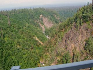
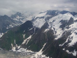
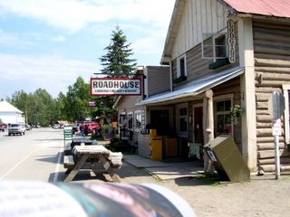
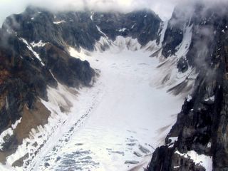
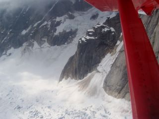
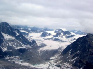
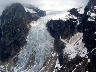
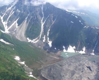
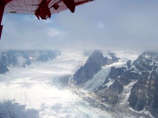
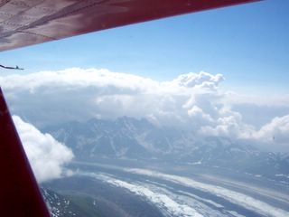
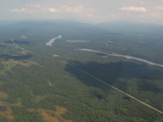
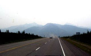
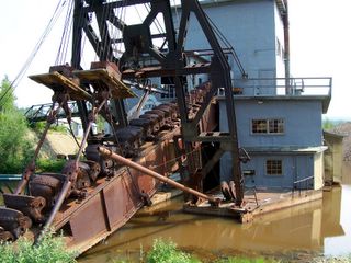
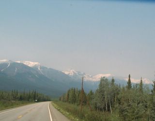
Leaving Denali we are traveling along the Nenana River in a Valley and along side are the Alaska Mountains, the highest in North America and they are majestic. They remain partially covered with snow and glaciers year round. The highway is a little better than yesterday. It is very hazy again today. We have found that most of the fires burning now were set by the Parks. This burning is done every year in different years to help the forest ecology. The mountains are not clear but are still beautiful. For most of the way we had trees on both sides of the road so were not seeing many mountains but they are spectacular now. We are staying in Talkeetna at the Talkeetna Camper Park for two nights. Talkeetna is the main staging area for those wanting to climb Mt. McKinley. The planes fly them up to the base of the mountain and they start their climb from there. There were about 160 climbers on the mountain while we were there and they had heavy rain in the lower part of the mountain and snow above 1700 feet. We listened to a lady give a seminar on climbing. We decided it was way out of our capability let alone our desire. Mt. McKinley can be seen from Talkeetna but only 80% of people who come here actually see it because of cloud cover. Gene ate Salmon Bake while here. He liked it. I like salmon cold out of the can but not much cooked. Our last morning we ate at the famous Roadhouse. They are known for their sourdough pancakes. These pancakes are about 12 inches in diameter. Yes, that is correct. Then later we took a flightseeing ride to the Mt. McKinley area. We had hoped to land on Ruth Glacier but the clouds were sitting on the floor of the glacier and the pilot thought it unsafe to land and or take off. It is quite awesome to see those big big mountains and the glaciated valleys. The mountains are above the tree line. They are granite and the wet Tundra valleys are covered with mosses and lichens. These huge mountains made us feel very small. As soon as we landed we left for Anchorage which is about 2 hours south. The road were in good shape. We did not see any mountains again until we were close to Anchorage. This is the Pacific Range. We had hoped to stay at Walmart for one night but they do not allow overnight parking so we are staying at the Golden Nugget Camper Park. We will be here for a week.
Thursday, June 30, 2005

Tuesday, June 28, 2005
6/28
As we leave Fairbanks this morning the sky is hazy as it was yesterday. The sun looked like a big orange ball in the sky. The haze is caused from some fires in the forests. We are heading to Denali. The highway has lots of permafrost damage. In fact just 8 miles out of Fairbanks we are on very bumpy gravel road and only able to travel about 25 miles an hour. We have to stop periodically for a pilot car. When we are on a paved road the permafrost has caused such heaves in the pavement it is like a giant washboard. As we move closer to Denali Park we are getting into the Alaska Range but the sky is so hazy we cannot enjoy them as we have before. Denali Park is about 200 miles from Fairbanks. We had hoped to stay at a Federal Campground in the park but they were all filled up. So we spent the night at the Denali Grizzly Bear Campground which was about 20 miles south of the park. Then we drove into Denali Park. Unless drivers have a special permit
they can only go 15 miles into the park. Anything beyond that has to be traveled by bus. In that first 15 miles there is not much to see. We had taken the bus trip when we took the inland tour part of our cruise which we were on a couple of years ago. We spent some time walking there an in the Denali Village which is a tourist trap just outside of the park. We of course took pictures of the area. Unlike most tourists Denali is not one of our favorite places to visit.
Monday, June 27, 2005
6/21 to 6/27
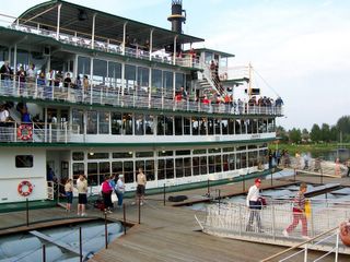
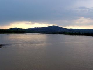
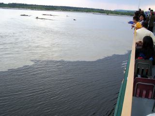
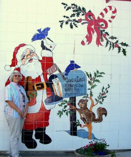
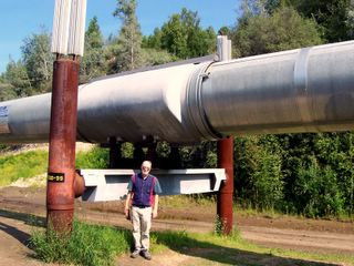
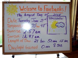
Some of the most beautiful mountains we have ever seen were just west of Tok. These very high mountains were snowcapped and just an awesome sight. Soon they were out of sight and for most of the rest of this 200 mile trip there was nothing spectacular to see. On our way we passed through North Pole. We are camped not far from there so we will go back there in a day or two to see Santa Claus. We are staying at the Roads End Campground and will be here for a week. We have cell phone service here but not internet service. Today 6/21 is Summer Solstice. Here in Fairbanks they have a celebration all day with a festival downtown and a baseball game at midnight without lights. On this day the sun here sets at 12:45 AM and sunrise is at 2:30 AM. More than 20 hours of day light. We did go to town and walked around the festival but the ballgame was way too late for us. It is a strange feeling to wake up in the night when it is light outside. On Thursday we took a side trip north to the Visitors Center for the Alyeska Oil Pipe Line. The pipe line is 800 miles long and is 48 inches in diameter. 380 miles are buried and the remainder is above ground a minimum of 5 feet allowing for uninhibited caribou migration. The pipe line is above ground in the permafrost areas. It is built with a zig zag pattern and was constructed so that it can shift from side to side to counteract the heave of the permafrost. It is designed to withstand earthquakes for 5.5 to 8.5 on the Richter Scale. At this time one million gallons of oil flow through the pipe line per day. It takes just over 6 days for the oil to flow from Prudhoe Bay to Valdez. We also went to the Santa Claus House in North Pole. We were disappointed because I expected to find toys there and Santa Claus. I had hoped to send a gift from there to our great granddaughter. But mostly all they sell is Christmas decorations and ornaments. This small town is growing as more and more people from Fairbanks migrate there. It is a strange feeling to wake up in the night when it is light outside. On Thursday we took a side trip north to the Visitors Center for the Alyeska Oil Pipe Line. The pipe line is 800 miles long and is 48 inches in diameter. 380 miles are buried and the remainder is above ground a minimum of 5 feet allowing for uninhibited caribou migration. The pipe line is above ground in the permafrost areas. It is built with a zig zag pattern and was constructed so that it can shift from side to side to counteract the heave of the permafrost. It is designed to withstand earthquakes for 5.5 to 8.5 on the Richter Scale. At this time one million gallons of oil flow through the pipe line per day. It takes just over 6 days for the oil to flow from Prudhoe Bay to Valdez. We also went to the Santa Claus House in North Pole. We were disappointed because I expected to find toys there and Santa Claus. I had hoped to send a gift from there to our great granddaughter. But mostly all they sell is Christmas decorations and ornaments. This small town is growing as more and more people from Fairbanks migrate there. We went on an evening cruise up the Chena and Nenana Rivers. Several facts about the area and the importance of the rivers to the people were given to us. It was a beautiful evening and a fun time. The Nenana River is spring fed and the Chena River is glacial fed. When these two rivers come together the glacial silt floats on the top. It is quite unusual to see this. Also we are able to observe any river and tell if it is glacial water.
Some of the most beautiful mountains we have ever seen were just west of Tok. These very high mountains were snowcapped and just an awesome sight. Soon they were out of sight and for most of the rest of this 200 mile trip there was nothing spectacular to see. On our way we passed through North Pole. We are camped not far from there so we will go back there in a day or two to see Santa Claus. We are staying at the Roads End Campground and will be here for a week. We have cell phone service here but not internet service. Today 6/21 is Summer Solstice. Here in Fairbanks they have a celebration all day with a festival downtown and a baseball game at midnight without lights. On this day the sun here sets at 12:45 AM and sunrise is at 2:30 AM. More than 20 hours of day light. We did go to town and walked around the festival but the ballgame was way too late for us. It is a strange feeling to wake up in the night when it is light outside. On Thursday we took a side trip north to the Visitors Center for the Alyeska Oil Pipe Line. The pipe line is 800 miles long and is 48 inches in diameter. 380 miles are buried and the remainder is above ground a minimum of 5 feet allowing for uninhibited caribou migration. The pipe line is above ground in the permafrost areas. It is built with a zig zag pattern and was constructed so that it can shift from side to side to counteract the heave of the permafrost. It is designed to withstand earthquakes for 5.5 to 8.5 on the Richter Scale. At this time one million gallons of oil flow through the pipe line per day. It takes just over 6 days for the oil to flow from Prudhoe Bay to Valdez. We also went to the Santa Claus House in North Pole. We were disappointed because I expected to find toys there and Santa Claus. I had hoped to send a gift from there to our great granddaughter. But mostly all they sell is Christmas decorations and ornaments. This small town is growing as more and more people from Fairbanks migrate there. It is a strange feeling to wake up in the night when it is light outside. On Thursday we took a side trip north to the Visitors Center for the Alyeska Oil Pipe Line. The pipe line is 800 miles long and is 48 inches in diameter. 380 miles are buried and the remainder is above ground a minimum of 5 feet allowing for uninhibited caribou migration. The pipe line is above ground in the permafrost areas. It is built with a zig zag pattern and was constructed so that it can shift from side to side to counteract the heave of the permafrost. It is designed to withstand earthquakes for 5.5 to 8.5 on the Richter Scale. At this time one million gallons of oil flow through the pipe line per day. It takes just over 6 days for the oil to flow from Prudhoe Bay to Valdez. We also went to the Santa Claus House in North Pole. We were disappointed because I expected to find toys there and Santa Claus. I had hoped to send a gift from there to our great granddaughter. But mostly all they sell is Christmas decorations and ornaments. This small town is growing as more and more people from Fairbanks migrate there. We went on an evening cruise up the Chena and Nenana Rivers. Several facts about the area and the importance of the rivers to the people were given to us. It was a beautiful evening and a fun time. The Nenana River is spring fed and the Chena River is glacial fed. When these two rivers come together the glacial silt floats on the top. It is quite unusual to see this. Also we are able to observe any river and tell if it is glacial water.
Sunday, June 26, 2005
Monday, June 20, 2005
6/19 to 6/20
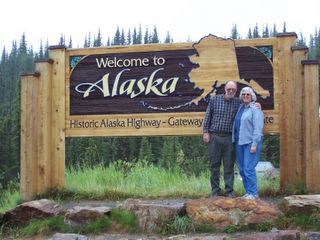
We will head into Alaska this morning. We started out on gravel for the first 4-5 miles then changed to black top which is in very bad condition. We are having to moving slowly. We are seeing damage on the highway done by the permafrost. Permafrost forms when the average soil temperature is 27 degrees. Ice slowly forms in poorly drained soils. One sign of existing permafrost is a black spruce bog. Black spruce are small, scraggly trees that can survive in the few inches of soil that thaws out above the permafrost. A tree of only 2 inches in diameter is often 100 years old. In a black spruce bog, a thick mat of mosses and other small plants covers the ground. This mat acts as a sponge that holds moisture and serves as insulation keeping the permafrost from melting.
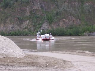
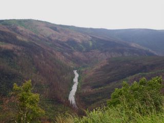
We see some waist-high vertical corrugated metal culverts topped with cone-shaped “hats” along the highway. They are an experiment to keep ground from thawing and thus prevent frost heaves. Hip, HIP, Hooray. We are in Alaska. The boundary line between Alaska and Yukon was originally described in an 1825 treaty between Russia and England. The U.S, accepted this version of the boundary with its purchase of Alaska from Russia in 1867. But after gold was discovered in the Klondike in 1896, a dispute arose between the U.S. and Canada, with both claiming the seaports at the head of Llynn Canal (Skagway). An international tribunal decided in favor of the U.S. in 1903. Now there is a narrow clearing going south to denote the border. Shortly after crossing the border we bought gasoline for $2.31. That is the lowest price we have paid since back in Washington. The roads here seem to be a little better than in Canada. We are staying in Tok at the Sourdough Campground. They serve sourdough pancakes for breakfast and sourdough bread bowls with chili or reindeer stew in the evening. They also have music entertainment each evening. These perks seem to draw a lot of people as their campground is full nearly every evening. We spent 2 nights. We went to the music show the first night which was quite good and the next night we had the chili bread bowl. It was raining so the whole affair was held inside. By the time we got there the restaurant was full and no one was leaving due to the music performance being there too. So we ate outside with 2 other couples and then went home. We took a side trip from Tok to Dawson City. It is about 165 miles but took 5 hours one way due to the road condition. The weather was cloudy and raining off and on. Shortly after we began our journey we could see evidence of a forest fire. This fire occurred in 2004 along with several other fires in Alaska. A total of 708 fires burned 6.7 million acres. It was the smokiest summer on record in more than 100 years. We stopped in the small town of Chicken which was named by early miners who wanted to name their camp ptarmigan, but were unable to spell it and settled instead for chicken, the common name in the North for ptarmigan. Chicken has a population of 37 people. It has 3 businesses, no phone or TV services and they receive their mail only twice a week. There are 2 campgrounds there so the area is swarming with tourists. We never did see any houses. They must be off the main road. About 10 miles before we arrived in Chicken the road turned into gravel clear to the Canadian border. From there to Dawson City it was paved but in very poor condition. We are very glad we did not take this route with the motorhome. This highway is called “The Top of the World Highway” It goes for many miles near the tops of the mountains and on a clear day provides beautiful views. Unfortunately it was very cloudy until we were very close to Dawson City. This highway ends at the Yukon River and we had to take a ferry across the river to the town of Dawson City. We walked around the downtown area and then found a place to eat. Again this town is styled from the 1990’s. There is not really much to do here but browse the gift shops. Since we don’t have anyplace to put things we don’t buy. Our trip home was on the same road. By the time we were close to home it was raining again.
We will head into Alaska this morning. We started out on gravel for the first 4-5 miles then changed to black top which is in very bad condition. We are having to moving slowly. We are seeing damage on the highway done by the permafrost. Permafrost forms when the average soil temperature is 27 degrees. Ice slowly forms in poorly drained soils. One sign of existing permafrost is a black spruce bog. Black spruce are small, scraggly trees that can survive in the few inches of soil that thaws out above the permafrost. A tree of only 2 inches in diameter is often 100 years old. In a black spruce bog, a thick mat of mosses and other small plants covers the ground. This mat acts as a sponge that holds moisture and serves as insulation keeping the permafrost from melting.
We see some waist-high vertical corrugated metal culverts topped with cone-shaped “hats” along the highway. They are an experiment to keep ground from thawing and thus prevent frost heaves. Hip, HIP, Hooray. We are in Alaska. The boundary line between Alaska and Yukon was originally described in an 1825 treaty between Russia and England. The U.S, accepted this version of the boundary with its purchase of Alaska from Russia in 1867. But after gold was discovered in the Klondike in 1896, a dispute arose between the U.S. and Canada, with both claiming the seaports at the head of Llynn Canal (Skagway). An international tribunal decided in favor of the U.S. in 1903. Now there is a narrow clearing going south to denote the border. Shortly after crossing the border we bought gasoline for $2.31. That is the lowest price we have paid since back in Washington. The roads here seem to be a little better than in Canada. We are staying in Tok at the Sourdough Campground. They serve sourdough pancakes for breakfast and sourdough bread bowls with chili or reindeer stew in the evening. They also have music entertainment each evening. These perks seem to draw a lot of people as their campground is full nearly every evening. We spent 2 nights. We went to the music show the first night which was quite good and the next night we had the chili bread bowl. It was raining so the whole affair was held inside. By the time we got there the restaurant was full and no one was leaving due to the music performance being there too. So we ate outside with 2 other couples and then went home. We took a side trip from Tok to Dawson City. It is about 165 miles but took 5 hours one way due to the road condition. The weather was cloudy and raining off and on. Shortly after we began our journey we could see evidence of a forest fire. This fire occurred in 2004 along with several other fires in Alaska. A total of 708 fires burned 6.7 million acres. It was the smokiest summer on record in more than 100 years. We stopped in the small town of Chicken which was named by early miners who wanted to name their camp ptarmigan, but were unable to spell it and settled instead for chicken, the common name in the North for ptarmigan. Chicken has a population of 37 people. It has 3 businesses, no phone or TV services and they receive their mail only twice a week. There are 2 campgrounds there so the area is swarming with tourists. We never did see any houses. They must be off the main road. About 10 miles before we arrived in Chicken the road turned into gravel clear to the Canadian border. From there to Dawson City it was paved but in very poor condition. We are very glad we did not take this route with the motorhome. This highway is called “The Top of the World Highway” It goes for many miles near the tops of the mountains and on a clear day provides beautiful views. Unfortunately it was very cloudy until we were very close to Dawson City. This highway ends at the Yukon River and we had to take a ferry across the river to the town of Dawson City. We walked around the downtown area and then found a place to eat. Again this town is styled from the 1990’s. There is not really much to do here but browse the gift shops. Since we don’t have anyplace to put things we don’t buy. Our trip home was on the same road. By the time we were close to home it was raining again.
Subscribe to:
Comments (Atom)
