7/28 to 7/31
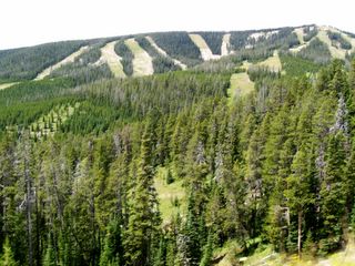
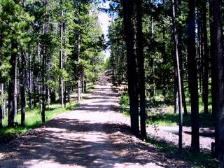
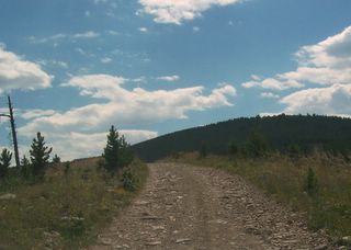
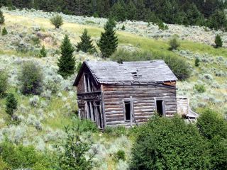
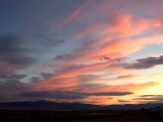
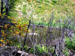
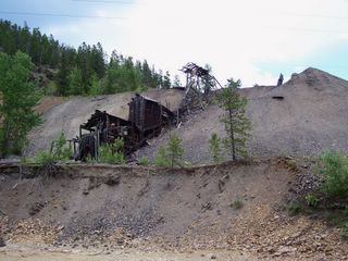
We are on Highway 89 which passes through the Lewis and Clark National Forest. We stopped to take pictures of the Sleuse Box Canyon which gets its name from a silver mine down the canyon. A sleuse box was used to get the silver out of the ore. It is a very pretty valley. We later passed through the two small towns where the silver was mined. We could see some of the abandoned mines. They, unlike many mining towns, are surviving and seem to have new residents. It is quite a ways to a city of any size for shopping. We have to wonder what the people living here do and why they would even want to live here. We have seen a couple of ski resorts, one named Showdown Ski Resort. We are staying in White Sulphur Springs for a few days. We will get our mail here. The springs here are located inside a motel!!! We took a side trip on a gravel road which went into the Lewis and Clark National Forest. It was a single lane road most of the way and quite bumpy. Our destination was an old abandoned silver mining town 19 miles away. It was a beautiful and interesting drive. Much of the time the road ran through private property and we were instructed to stay on the road. We did not see any wildlife but lots of wildflowers. It was a fun trip. We had WiFi while at this campground so I was able to almost get caught up on “Our Travels We moved our RV to a spot at a motel for two more days in this little burg. We saw a beautiful Montana Sunset. We went to an old Victorian home that is now open for tours. It was built around the turn of the century by a mine owner. It was quite extravagant in its day. We also took a side trip back to the silver mine area we had passed through on Thursday. We thought there might be some points of interest there but saw very little. We did see the remains of an old mine shaft. Along the way we saw an area where beaver had built several dams and lodges. We have done much reading and resting and ready to hit the road again tomorrow.
Sunday, July 31, 2005

Wednesday, July 27, 2005
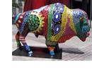
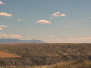
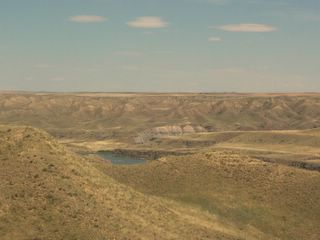
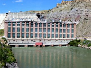
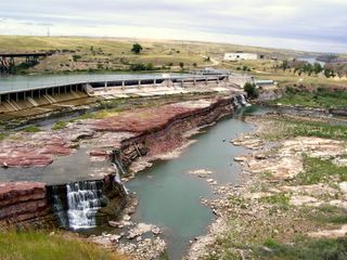
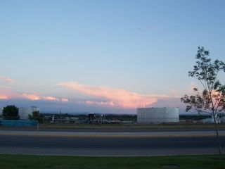
7/23 to 7/28Today, Saturday, we moved the RV to the fair grounds and signed up for 5 days. We want to rest up some since we were on the move for almost a week. There are five falls here known as the “Great Falls of the Missouri. Great Falls, Montana is centrally located along the 4000 mile Lewis and Clark National Historic Trail. In 1803 President Jefferson commissioned Merriweather Lewis to find a suitable water route to the west coast. Lewis and Clark left St. Louis in 1804 by boat to find that route. At sunrise on June 13, 1805 Captain Meriwether Lewis left the Corps of the Delivery at what is now Belt Creek in search of the falls Indians had told them were ahead. The Indians referred to them as the Great Falls. He traveled about 6 miles. In his journal he recorded, “Whin my ears were saluted with the agreeable sound of a fall of water, advancing a little further, I saw the spray arise above the plains like a column of smoke which would frequently disappear in an instant – which soon began to make a roaring to be mistaken for any cause short of the great falls of the Missouri.” The falls were more than 80 feet giving him a view that he described as “the grandest sight I had ever beheld.” The next day he continued upstream and discovered a second set of falls, this one 19 feet high and 100 yards across. As he continued up the river he found 3 more falls. Since there was no way to get their boats up these falls, Lewis and Clark and Company “portaged” the boats over land which means they built trailers from local trees to haul the boats. The banks of the river at the falls were very high. They found a location where a creek, which Lewis named Portage Creek, flowed into the Missouri. The banks of this creek sloped gradually to the creek so they were able to begin the 18 mile portage around the Great Falls. It took them much longer than Lewis had originally thought due to the rolling terrain they had to cross. There is a Lewis and Clark Interpretive Center in Great Falls. We watched documentaries about the falls and the trail in the area. They also gave us lots of information about the Indians as they were a great help to them. It was very interesting to us. We also drove to see most of the falls. Three of these falls now have a hydroelectric dam on them and there are two other hydroelectric dams within the area. This hydroelectric power provides electricity for ½ of Montana. Most of the days while here it was pretty hot. Great Falls has a number of Buffalo Statues around their city. These are a fund raiser for the city.. It is our understanding several cities are doing this. The city furnishes the statue and citizens paint the statue and give it an appropriate name. Then at a later date they are auctioned off to the highest bidder.. Great Falls hosts the Montana State Fair and it starts the day after we leave, 7/29. In the evenings we walked around the big fair grounds to see the preparations for the State Fair

Friday, July 22, 2005
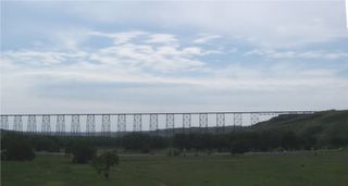
7/22
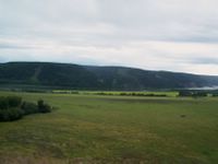
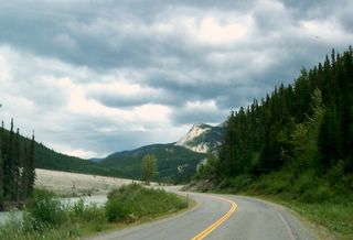
It is cloudy this morning. They grow several crops here and have cattle and horses. One of the crops which has yellow flowers is Canola. Another has red flowers but we did not find out what it is. Lethbridge, a town we passed through, has an interesting history. In 1869, the American Army decided to stop trade in alcohol with Indians on reservations across Montana. Two American traders built a trading post near the future site of Lethbridge. The post became known as Fort Whoop-Up. An important trade commodity was “whiskey” a concoction of 9 parts river water to 1 part pure alcohol, to which was added a plug of chewing tobacco for color and a can of lye for more taste. Alarmed by the activities there the Mounted Police came to bring law and order to the area and immediately put a stop to the whisky trade. Lethbridge has a railroad bridge which was built in 1909. The bridge, -- with a mile long span and 300-ft. elevation – is still the longest and highest bridge of its kind in the world. We passed through the US Customs with no problems. We are very glad to be back in the “lower 48”. No more converting kilometers, litres and Canadian/ US money. We entered Canada on our way to Alaska on 6/2 which makes it just over 3 weeks we were there. During that time we drove 4,625 miles in the RV. That does not include the side trips we took in the pickup. This area of Montana is very flat. It seems quite warm this afternoon. We may be getting into some hot weather which we are not used to. Now the wind has started blowing quite hard. Dorothy, maybe we are back in Kansas. We will be staying in Great Falls, MT. We stayed tonight at Walmart. We learned at the Tourist Info Center the State Fair Grounds has a small RV Campground so we will plan to stay there for a few days.
It is cloudy this morning. They grow several crops here and have cattle and horses. One of the crops which has yellow flowers is Canola. Another has red flowers but we did not find out what it is. Lethbridge, a town we passed through, has an interesting history. In 1869, the American Army decided to stop trade in alcohol with Indians on reservations across Montana. Two American traders built a trading post near the future site of Lethbridge. The post became known as Fort Whoop-Up. An important trade commodity was “whiskey” a concoction of 9 parts river water to 1 part pure alcohol, to which was added a plug of chewing tobacco for color and a can of lye for more taste. Alarmed by the activities there the Mounted Police came to bring law and order to the area and immediately put a stop to the whisky trade. Lethbridge has a railroad bridge which was built in 1909. The bridge, -- with a mile long span and 300-ft. elevation – is still the longest and highest bridge of its kind in the world. We passed through the US Customs with no problems. We are very glad to be back in the “lower 48”. No more converting kilometers, litres and Canadian/ US money. We entered Canada on our way to Alaska on 6/2 which makes it just over 3 weeks we were there. During that time we drove 4,625 miles in the RV. That does not include the side trips we took in the pickup. This area of Montana is very flat. It seems quite warm this afternoon. We may be getting into some hot weather which we are not used to. Now the wind has started blowing quite hard. Dorothy, maybe we are back in Kansas. We will be staying in Great Falls, MT. We stayed tonight at Walmart. We learned at the Tourist Info Center the State Fair Grounds has a small RV Campground so we will plan to stay there for a few days.
Thursday, July 21, 2005
7/21
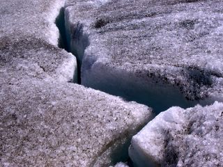
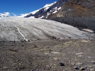
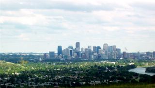
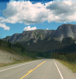
The mountains here in Jasper and Banf National Parks are quite high so there are many with glaciers. One of the highlights of our day was Columbia Glacier. A glacier is a mass of ice which is a least 300 feet thick and moves under the force of gravity. An icefield is a sheet of glacial ice that is trapped by higher surrounding land and which feeds more than one glacier. The Columbia Icefield is one such “lake of ice” and feeds six large glaciers one of which is Columbia. We were able to walk on the glacier but had to walk up hill about ½ mile. As we stepped out on the glacier, we had to climb up hill more. We did not go more than a block as we were afraid one of us might slip and fall. It was an awesome experience. There were many warnings about not walking outside the roped in area. One of the information boards told of a 4 year old boy who in 2001 wandered off from his parents and fell in a crevasse. He was dead of hypothermia before they could rescue him 3 hours later. We saw many majestic mountains, beautiful rivers, emerald lakes, and amazing waterfalls. The awesomeness of God is displayed in these Canadian Rockies. We have learned much about God’s creation while north of the “lower 48”. It had rained off and on for the past 3 days but just as we got to the Park, the sun came out and it was a spectacular day. Thank You, Lord. Shortly after passing through the Park gates it begin to cloud up. We drove on to Calvary where we passed beside the 1988 Olympic Village. We saw the luge track and the ski jumps. We stayed the night at the city park in High River, Montana.
The mountains here in Jasper and Banf National Parks are quite high so there are many with glaciers. One of the highlights of our day was Columbia Glacier. A glacier is a mass of ice which is a least 300 feet thick and moves under the force of gravity. An icefield is a sheet of glacial ice that is trapped by higher surrounding land and which feeds more than one glacier. The Columbia Icefield is one such “lake of ice” and feeds six large glaciers one of which is Columbia. We were able to walk on the glacier but had to walk up hill about ½ mile. As we stepped out on the glacier, we had to climb up hill more. We did not go more than a block as we were afraid one of us might slip and fall. It was an awesome experience. There were many warnings about not walking outside the roped in area. One of the information boards told of a 4 year old boy who in 2001 wandered off from his parents and fell in a crevasse. He was dead of hypothermia before they could rescue him 3 hours later. We saw many majestic mountains, beautiful rivers, emerald lakes, and amazing waterfalls. The awesomeness of God is displayed in these Canadian Rockies. We have learned much about God’s creation while north of the “lower 48”. It had rained off and on for the past 3 days but just as we got to the Park, the sun came out and it was a spectacular day. Thank You, Lord. Shortly after passing through the Park gates it begin to cloud up. We drove on to Calvary where we passed beside the 1988 Olympic Village. We saw the luge track and the ski jumps. We stayed the night at the city park in High River, Montana.

Wednesday, July 20, 2005
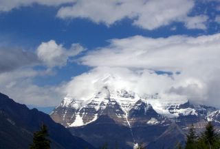
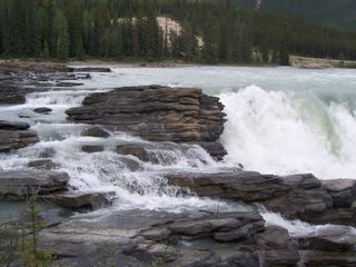
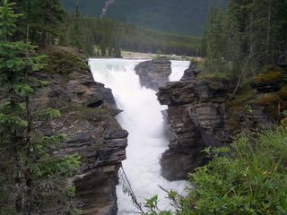
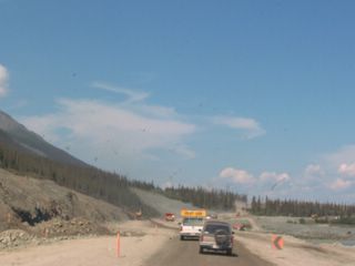
7/20 It was raining when we woke up. We made our way to the Ford dealer. It took about 2 hours to finish the job and we were on our way. The problem was the same we had in December but this time they replaced more parts which should have been done before. This road out of Prince George to Jasper we have not been on before. We are traveling east so that we can go down through the Rocky Mountains that are supposed to so very beautiful. Along the way a moose walked out in front of the RV and Gene honked at him to get him moving. This area has been infested with the Hemlock Looper which has killed or damaged 45.9 million cubic ft. of wood in British Columbia. As we get closer to Jasper the mountains are big and beautiful. Since it is raining I can’t take pictures from inside the RV due to the rain on the windshield. We stopped so that we could take pictures of Mt. Robson, a very majestic view. Another mountain here is named for a young man who had bone cancer and the day after his leg was amputated above the knee, he began making plans to walk across Canada to raise money for cancer. He trained for one complete summer. His run across Canada was like running a marathon each day. He made it ½ way and was forced to quit because his cancer had returned. He earned $25 million during his attempt. When arriving in Jasper we were surprised to find out we would have to pay $32 for two days in the National Park not including camping fees. We stayed at Grizzly Bear Campground within the park. After eating we drove to see the Athabaska Falls. It was quite unique and interesting. It falls out of the river and down into a deep canyon. There were several different places to view the falls. Most amazing.
Tuesday, July 19, 2005
7/19
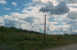
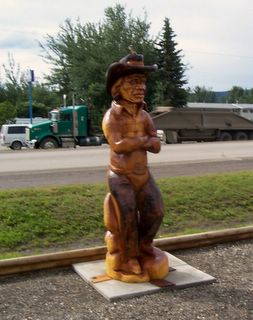
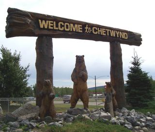
It rained most of the night and off and on through the day. The roads were pretty bad for a while but soon we were on freshly laid asphalt for a few miles. We did not know until we were on the road this morning the significance of another dam in the area. The 100-million-ton dam is one of the largest earth-fill structures in the world, and Williston Lake, behind it is the largest body of fresh water in British Columbia. The dam provides 30 percent of British Columbia’s hydroelectricity. Coming out of the area are 3 rows of utility towers which each carry 12 lines. These go up and down the mountains and through the valleys over much of BC. They give tours of this dam facility. Had we known that earlier we would have planned to take it but we were down the road a long ways before I read about it. Along the way we saw a beautiful big moose with a nice rack. The town of Chetwynd is known as the Chain Saw Sculpture Capital of the World. There are some 45 sculptures on display throughout the town. I took pictures of the ones at the Info Center. There is also a very large lumber mill here as well as a modern non-polluting paper mill. We made our way on into Prince George where we hope to stay the night at Walmart. We stopped to get gas as we first got to town. When Gene left the station he noticed the speedometer was not working and the engine light was on. We swung by the Ford dealer and made an appointment for the next morning to have it fixed. Then, we went to Walmart but there we found signs saying No Overnight Parking.!! So we went to a Campground that we thought was ½ price. As it turned out the ½ price was for the winter time. (like anyone would want to come here in the winter time). Here we are trying to save some money (economical) and we end up paying about as much as we have ever paid. It was nice to have electricity though and we could watch TV. We even used their bath house to take showers.
It rained most of the night and off and on through the day. The roads were pretty bad for a while but soon we were on freshly laid asphalt for a few miles. We did not know until we were on the road this morning the significance of another dam in the area. The 100-million-ton dam is one of the largest earth-fill structures in the world, and Williston Lake, behind it is the largest body of fresh water in British Columbia. The dam provides 30 percent of British Columbia’s hydroelectricity. Coming out of the area are 3 rows of utility towers which each carry 12 lines. These go up and down the mountains and through the valleys over much of BC. They give tours of this dam facility. Had we known that earlier we would have planned to take it but we were down the road a long ways before I read about it. Along the way we saw a beautiful big moose with a nice rack. The town of Chetwynd is known as the Chain Saw Sculpture Capital of the World. There are some 45 sculptures on display throughout the town. I took pictures of the ones at the Info Center. There is also a very large lumber mill here as well as a modern non-polluting paper mill. We made our way on into Prince George where we hope to stay the night at Walmart. We stopped to get gas as we first got to town. When Gene left the station he noticed the speedometer was not working and the engine light was on. We swung by the Ford dealer and made an appointment for the next morning to have it fixed. Then, we went to Walmart but there we found signs saying No Overnight Parking.!! So we went to a Campground that we thought was ½ price. As it turned out the ½ price was for the winter time. (like anyone would want to come here in the winter time). Here we are trying to save some money (economical) and we end up paying about as much as we have ever paid. It was nice to have electricity though and we could watch TV. We even used their bath house to take showers.
Monday, July 18, 2005
7/18
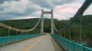
In the morning we did our laundry and at noon went to the library to check email and do some internet business. Then we ate lunch and by 1 pm we were on the road, a road with tall trees on both sides and an occasional view of mountains. At the end of the day we begin to see civilization again. Outside of Dawson Creek several miles we took a side road that cut off several miles. It was beautiful countryside with unusual hill formations. The Peace River runs through the valley. .Crops are growing and livestock graze the fields. Parts of the roads were very bumpy but it was worth the detour for the beauty. As we rose up out of the valley we crossed the river on a beautiful suspension bridge. At the west end of the river was the Bennet Dam. We stayed the night at a rest area just a few miles from Chetwynd, BC.
In the morning we did our laundry and at noon went to the library to check email and do some internet business. Then we ate lunch and by 1 pm we were on the road, a road with tall trees on both sides and an occasional view of mountains. At the end of the day we begin to see civilization again. Outside of Dawson Creek several miles we took a side road that cut off several miles. It was beautiful countryside with unusual hill formations. The Peace River runs through the valley. .Crops are growing and livestock graze the fields. Parts of the roads were very bumpy but it was worth the detour for the beauty. As we rose up out of the valley we crossed the river on a beautiful suspension bridge. At the west end of the river was the Bennet Dam. We stayed the night at a rest area just a few miles from Chetwynd, BC.
Sunday, July 17, 2005
7/17
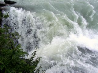
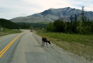
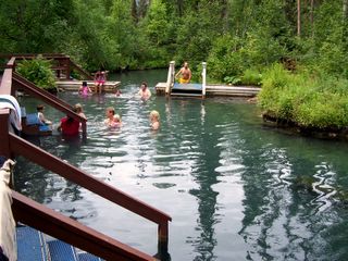
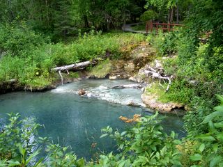
On our way to Liard Hot Springs we stopped by the Liard Cranberry Rapids. Not sure how the rapids got their name. They were much more spectacular than the picture that I took. The hot springs were in a government park so we had to pay just to see them. There were two pools. One was so hot the instructions said to only stay in one minute. The other was 130 degrees coming out of the ground and then was cooled gradually to 108 degrees. Then it poured down into the creek and cooled rapidly. Big problem: Mosquitoes were all over and all over any part of our body out of the water. The water was not very deep so we found a bench to sit on and enjoy the hot springs for about 15 to 20 minutes. That was our excitement for the day. We did see Caribou three different times and a Moose. We made it to Fort Nelson, BC. When we were there before we had seen other RV’s parked on the street and thought we would do that but we saw signs that said “no overnight parking” so we did not want to do that. Gene bought gas and asked the clerk if there was any place we could park for free (economical). They allowed us to park in their parking lot.
On our way to Liard Hot Springs we stopped by the Liard Cranberry Rapids. Not sure how the rapids got their name. They were much more spectacular than the picture that I took. The hot springs were in a government park so we had to pay just to see them. There were two pools. One was so hot the instructions said to only stay in one minute. The other was 130 degrees coming out of the ground and then was cooled gradually to 108 degrees. Then it poured down into the creek and cooled rapidly. Big problem: Mosquitoes were all over and all over any part of our body out of the water. The water was not very deep so we found a bench to sit on and enjoy the hot springs for about 15 to 20 minutes. That was our excitement for the day. We did see Caribou three different times and a Moose. We made it to Fort Nelson, BC. When we were there before we had seen other RV’s parked on the street and thought we would do that but we saw signs that said “no overnight parking” so we did not want to do that. Gene bought gas and asked the clerk if there was any place we could park for free (economical). They allowed us to park in their parking lot.
Saturday, July 16, 2005
7/16
It is raining again this morning. Since we never see a sunset here in Alaska I have been taking pictures of clouds. There are usually clouds over the mountains and they are most often spectacular views. In many areas along side the highway are trails that are used for 4 wheelers, snowmobiles and cross country skiers in winter. We stopped at Mukluk Annie’s Salmon Bake to fill our water tank and dump (economical). That is the place that let people stay overnight for free. We took them up on it on our way to Alaska. We stopped at a road side park beside a river to spend the night. The mosquitoes were the worst we have ever seen. They just swarmed in the RV when we opened the door so we did not go out again. The screens would have 10 to 15 mosquitoes just waiting for us to come out.
It is raining again this morning. Since we never see a sunset here in Alaska I have been taking pictures of clouds. There are usually clouds over the mountains and they are most often spectacular views. In many areas along side the highway are trails that are used for 4 wheelers, snowmobiles and cross country skiers in winter. We stopped at Mukluk Annie’s Salmon Bake to fill our water tank and dump (economical). That is the place that let people stay overnight for free. We took them up on it on our way to Alaska. We stopped at a road side park beside a river to spend the night. The mosquitoes were the worst we have ever seen. They just swarmed in the RV when we opened the door so we did not go out again. The screens would have 10 to 15 mosquitoes just waiting for us to come out.

Friday, July 15, 2005
7/15
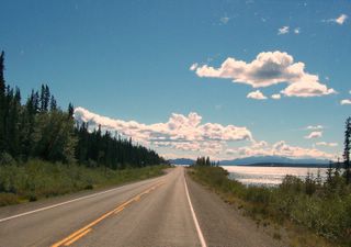
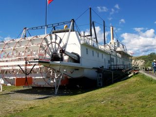
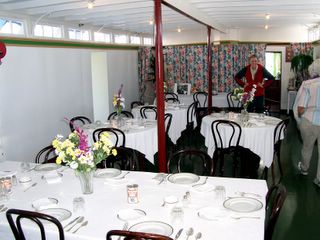
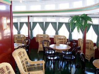
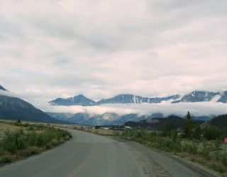
As we leave this morning there is a gentle rain and the clouds are hanging down over the mountains. It is so beautiful. There is lots of road construction at Destruction Bay and Haines Junction. We are staying at Walmart in Whitehorse. Tomorrow we plan to tour the SS Klondike which is located in Whitehorse. The Klondike, a steam powered stern wheel built in 1929, carried mail, general supplies, passengers and lead ore along the Yukon River between Whitehorse and Dawson City. The ship has been completely renovated. It could carry as many as 72 passengers though it rarely did so. The cost for a 1st class passenger for the 4 ½ day trip upriver from Dawson City to Whitehorse was $50. That was quite pricy for those days. The Yukon River is quite impressive. It is nearly 2000 miles long draining ¾ of the Yukon Territory and 1/3 of Alaska. It travels northwest from its head waters near the Yukon / British Columbia border to Ft. Yukon in Alaska. From there it turns sharply southwest and empties into the Bering Sea. It is bridged only 3 times in the Yukon and once in Alaska. It remains a way of life for those people living in the bush.
As we leave this morning there is a gentle rain and the clouds are hanging down over the mountains. It is so beautiful. There is lots of road construction at Destruction Bay and Haines Junction. We are staying at Walmart in Whitehorse. Tomorrow we plan to tour the SS Klondike which is located in Whitehorse. The Klondike, a steam powered stern wheel built in 1929, carried mail, general supplies, passengers and lead ore along the Yukon River between Whitehorse and Dawson City. The ship has been completely renovated. It could carry as many as 72 passengers though it rarely did so. The cost for a 1st class passenger for the 4 ½ day trip upriver from Dawson City to Whitehorse was $50. That was quite pricy for those days. The Yukon River is quite impressive. It is nearly 2000 miles long draining ¾ of the Yukon Territory and 1/3 of Alaska. It travels northwest from its head waters near the Yukon / British Columbia border to Ft. Yukon in Alaska. From there it turns sharply southwest and empties into the Bering Sea. It is bridged only 3 times in the Yukon and once in Alaska. It remains a way of life for those people living in the bush.
Thursday, July 14, 2005
7/14
The mail came in at the Tok Post Office about noon and we picked it up about 12:30 and were on our way. Tok is not a town we would like to live in. It is mostly RV parks, restaurants and gift shops and don’t forget lots of mosquitos. It seems it would be very boring for the locals, especially the kids. We are officially on our way home as we are traveling over the same roads. We passed through Canada Customs with no problems. The lady told us we could probably stay overnight at the highway pull-offs so we will try to do that to save a little money. For the most part we have decided the roads in Canada are worse than Alaska except for a couple of exceptions. We stopped for the night at a road side park 200 miles from Whitehorse in the Kluane Mountains.
The mail came in at the Tok Post Office about noon and we picked it up about 12:30 and were on our way. Tok is not a town we would like to live in. It is mostly RV parks, restaurants and gift shops and don’t forget lots of mosquitos. It seems it would be very boring for the locals, especially the kids. We are officially on our way home as we are traveling over the same roads. We passed through Canada Customs with no problems. The lady told us we could probably stay overnight at the highway pull-offs so we will try to do that to save a little money. For the most part we have decided the roads in Canada are worse than Alaska except for a couple of exceptions. We stopped for the night at a road side park 200 miles from Whitehorse in the Kluane Mountains.
Wednesday, July 13, 2005
7/12 & 7/13
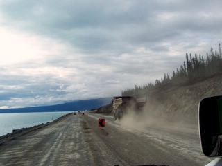
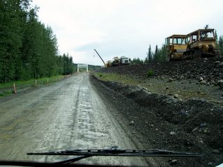
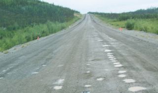
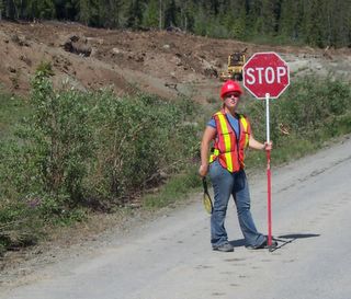
Today we travel along the West side of the Wrangell Mountains which are beautiful. The roads are very rough. Eventually we came to an area (about 10 miles) of gravel with big pot holes and boulders in the road way. We could only drive about 25 MPH max. Then we had to stop to wait for a pilot car. The road ahead was more like a trail than a road. But at last we were on blacktop. No, no…the blacktop only lasted about 2 blocks and for the next 5 miles or so we alternated between gravel and blacktop. That is sort of the pattern here in Alaska. When the highway gets severely damaged from permafrost they just dig up that section of blacktop and put in gravel. Then leave it that way until the whole road needs to be redone. We had many miles today of these same kinds of road conditions. Please notice the raquet the girl in the last picture has in her hand. It is for zapping mosquitoes!! Some places they are that bad. We bought one recently but have not needed it so far. Some places we were at we really did need one for each hand. We are between 2 mountain ranges and the valley between has many ponds and small lakes. The wild flowers are gone and the road side is drying up. As we arrive in Tok we have made a complete loop through Alaska. We stayed at Golden Bear CG in Tok, Alaska. We were waiting on our mail from the states. We hope the mail will be in tomorrow so we can get on the road but it may be later in the week.
Today we travel along the West side of the Wrangell Mountains which are beautiful. The roads are very rough. Eventually we came to an area (about 10 miles) of gravel with big pot holes and boulders in the road way. We could only drive about 25 MPH max. Then we had to stop to wait for a pilot car. The road ahead was more like a trail than a road. But at last we were on blacktop. No, no…the blacktop only lasted about 2 blocks and for the next 5 miles or so we alternated between gravel and blacktop. That is sort of the pattern here in Alaska. When the highway gets severely damaged from permafrost they just dig up that section of blacktop and put in gravel. Then leave it that way until the whole road needs to be redone. We had many miles today of these same kinds of road conditions. Please notice the raquet the girl in the last picture has in her hand. It is for zapping mosquitoes!! Some places they are that bad. We bought one recently but have not needed it so far. Some places we were at we really did need one for each hand. We are between 2 mountain ranges and the valley between has many ponds and small lakes. The wild flowers are gone and the road side is drying up. As we arrive in Tok we have made a complete loop through Alaska. We stayed at Golden Bear CG in Tok, Alaska. We were waiting on our mail from the states. We hope the mail will be in tomorrow so we can get on the road but it may be later in the week.


Subscribe to:
Posts (Atom)
